
(Click on any image below for a larger version)
Thursday, January 25: Deception Island
Thursday morning dawned cloudy, but the overcast soon gave way to scattered clouds and sunlight as we approached Deception Island. The island is an intermittently active volcano. The central crater of Deception Island is a caldera. So much material erupted from the magma chamber under the volcano that it has collapsed into itself.
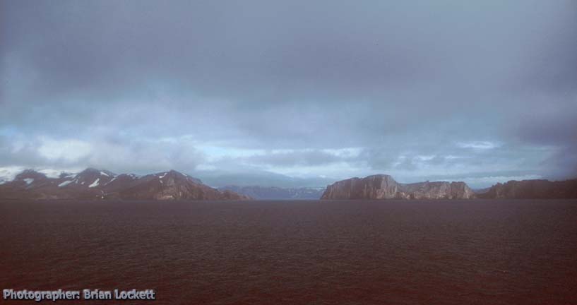 One part of
the crater wall has subsided below sea level, creating an
entrance into the large harbor in the caldera.
One part of
the crater wall has subsided below sea level, creating an
entrance into the large harbor in the caldera.
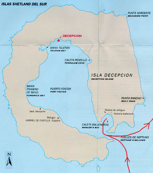 The
harbor is called Port Foster. This map is copied from Antarctic
Peninsula Map, published by Zagier & Urruty Publications of
Argentina.
The
harbor is called Port Foster. This map is copied from Antarctic
Peninsula Map, published by Zagier & Urruty Publications of
Argentina.

 The entrance into the harbor is called Neptune's Bellows.
Eruptions at Deception Island have been recorded frequently over the last two hundred years. The last major eruptions were in 1969-70.
Link to the Smithsonian Institute's Volcanic Activity Report for Deception Island.
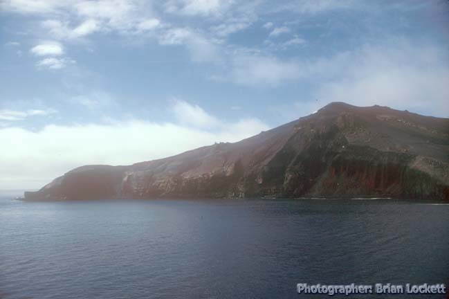
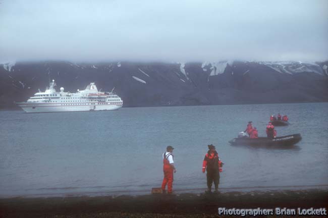
Another expedition ship could be seen laying off to the east of the island as Captain Notke carefully steered the Hanseatic into Neptune's Bellows.
The island was mostly free of snow and ice. There were hints of green grass or mosses and lichens on many of its slopes. The air temperature was nearly forty degrees F. and the wind was blowing about forty miles per hour.
The volcanic rocks making up the cliffs on either side of Neptune's Bellows are colored bright red and yellow. The cliffs harbor a large population of Cape Petrels and Kelp Gulls.
Flocks of birds were resting on the water in and around the entrance to the bay. It sounded like the soundtrack to Hitchcock's "The Birds". White guano stained the upper surfaces of all the rocks.
Our destination was Whaler's Bay, just inside the mouth of the harbor on the east side of the island. It is the site of an old whaling station and a British Antarctic Survey base. Both are abandoned.
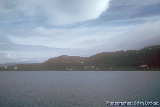 The ship steered toward a cluster of deteriorating buildings on
the shore. Steam was rising from a large lake and from parts of
the black sand beach. Antarctic Fur Seals were lounging on the
shore. Some of the young males were engaging in discussions of
territory issues.
The ship steered toward a cluster of deteriorating buildings on
the shore. Steam was rising from a large lake and from parts of
the black sand beach. Antarctic Fur Seals were lounging on the
shore. Some of the young males were engaging in discussions of
territory issues.
A stiff breeze was blowing as we observed the old whaling station and British Antarctic Survey base. The base had been abandoned during the last eruptions in 1969. The entire base was covered in volcanic ash from the eruptions that caused its abandonment. The largest building was the old airplane hangar. It was constructed of metal and had weathered the years fairly well. Other wooden structures of the outpost were in various states of decomposition.
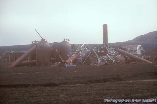
The tanks of the whale blubber rendering plant were surrounded by the remains of collapsed wooden buildings. Large, rusting whale oil storage tanks sat on the shore. One of them had been tipped part way over by floods of glacial melt water during the eruptions. We were told that at least one of the tanks had been washed all the way into the bay.
Onshore, the ship's staff had dug a hole in the sand of the beach. Water collected in the hole. Geothermal heat quickly made the water warm enough for people to soak in.
Part of the wall of the caldera near Neptune's Bellows has collapsed, leaving a low point called Neptune's Window. Debbie and I turned toward Neptune's Window and hiked up the beach. A cloudy overcast blew into the interior of the island.
 The rotting hulks of small wooden
boats were scattered along the beach.
The rotting hulks of small wooden
boats were scattered along the beach.
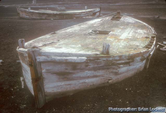 They had been water boats. They were used to
take loads of ice and snow to the whaling ships offshore to be
melted for fresh water. Erosion of the volcanic ash had exposed
several small wooden buildings. Some of them were relatively
intact. The walls of some of the buildings had collapsed, leaving
the roofs lying on piles of broken timbers.
They had been water boats. They were used to
take loads of ice and snow to the whaling ships offshore to be
melted for fresh water. Erosion of the volcanic ash had exposed
several small wooden buildings. Some of them were relatively
intact. The walls of some of the buildings had collapsed, leaving
the roofs lying on piles of broken timbers.
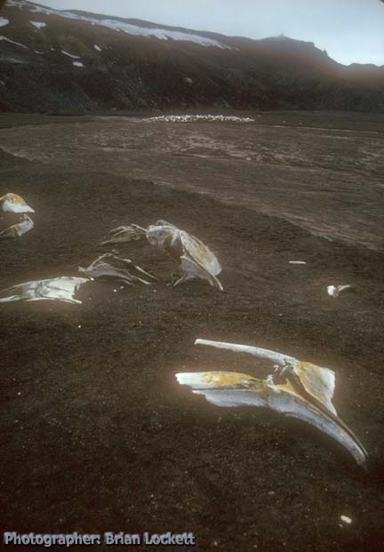 Very soon we came across whale bones eroding
out of the volcanic ash. A short distance away we saw a large
pile of what appeared to be more whale bones.
Very soon we came across whale bones eroding
out of the volcanic ash. A short distance away we saw a large
pile of what appeared to be more whale bones.
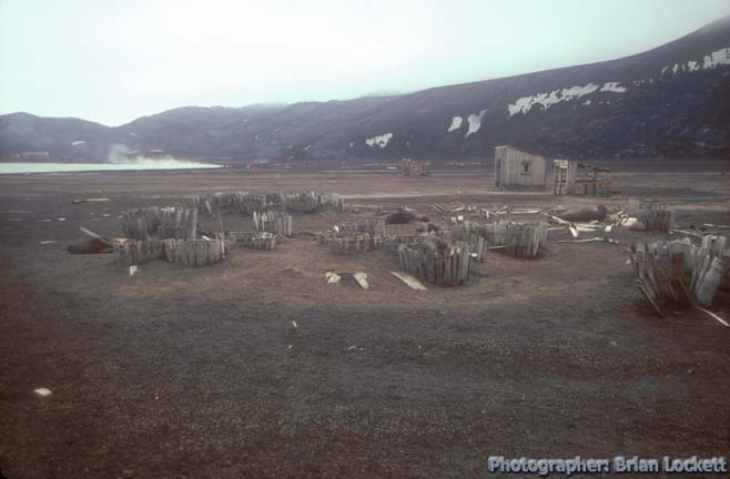
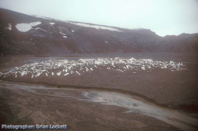 On closer examination they turned
out to be old whale oil barrels. The pile of barrels had been
buried during volcanic eruptions. Now the barrels are eroding out
of the ash again.
On closer examination they turned
out to be old whale oil barrels. The pile of barrels had been
buried during volcanic eruptions. Now the barrels are eroding out
of the ash again.
 A solitary Weddell Seal was basking on the
beach, where it was warmed by the geothermal heat.
A solitary Weddell Seal was basking on the
beach, where it was warmed by the geothermal heat.
Link to information about the Weddell Seal from the Sierra Club Handbook of Seals and Sirenians.
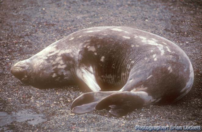 It stretched sleepily to scratch its tail
flipper with a pectoral fin.
It stretched sleepily to scratch its tail
flipper with a pectoral fin.
Farther down the beach, a group of Antarctic Fur Seals were lying about.
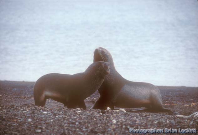 Occasionally, a pair of male Fur
Seals would engage in some roughhousing, but mostly they just
slept peacefully.
Occasionally, a pair of male Fur
Seals would engage in some roughhousing, but mostly they just
slept peacefully.
Link to information about the Antarctic Fur Seal at Antarctic Adventure.
Jaap van der Toorn has created a page describing the various Fur Seals.
Dad had arrived at Neptune's Window a little while before me. After chatting for a bit, he started down the trail and hiked along the beach to the British outpost in the distance.
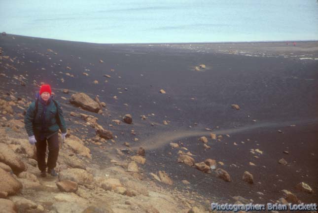 Just after he headed down, I
spotted Debbie hiking up by a different route.
Just after he headed down, I
spotted Debbie hiking up by a different route.
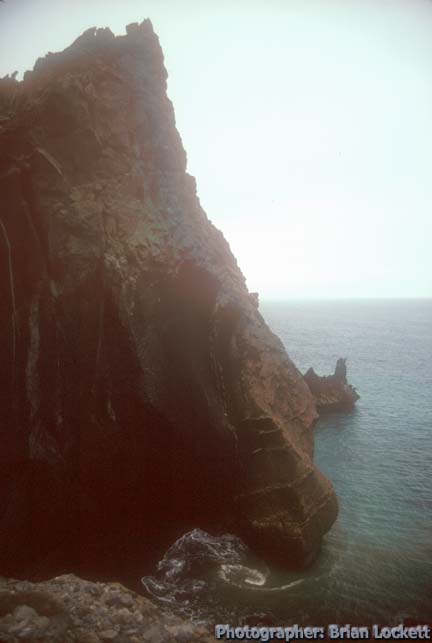 The low point in the caldera rim provided a view of a cove on the
outer shore of the island. Cape Petrels were nesting in the crags
of the cliff faces. A strong wind blew in through the window from
the open sea beyond. The petrels rode the lift from the wind
rising to the window to reach their nesting area. When they
turned to face the incoming wind, they stopped beating their
wings and glided on the turbulent currents. The turbulence
required them to make many small, rapid adjustments of their
wings and tail to maintain their position next to the cliff face.
The low point in the caldera rim provided a view of a cove on the
outer shore of the island. Cape Petrels were nesting in the crags
of the cliff faces. A strong wind blew in through the window from
the open sea beyond. The petrels rode the lift from the wind
rising to the window to reach their nesting area. When they
turned to face the incoming wind, they stopped beating their
wings and glided on the turbulent currents. The turbulence
required them to make many small, rapid adjustments of their
wings and tail to maintain their position next to the cliff face.
 I handed my camera to Debbie to have her take
another picture of me. We observed the petrels for a while longer
and then followed the trail that Dad had taken down to the beach.
I handed my camera to Debbie to have her take
another picture of me. We observed the petrels for a while longer
and then followed the trail that Dad had taken down to the beach.
 Fur seals were resting among a pile
of old whale oil barrels.
Fur seals were resting among a pile
of old whale oil barrels.
 One of them was curled up inside
the remains of a partially collapsed barrel. It paid scant
attention to me as I took its picture, but a male seal that had
been napping nearby lifted its head and began huffing its
indignation at me for disturbing its rest.
One of them was curled up inside
the remains of a partially collapsed barrel. It paid scant
attention to me as I took its picture, but a male seal that had
been napping nearby lifted its head and began huffing its
indignation at me for disturbing its rest.
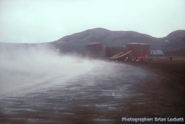 Debbie and I hiked back toward the
Zodiac landing. A cold, misty wind was blowing down from the
glaciers on the rim of the caldera, which resulted in copious
quantities of steam rising from the warm sand of the beach.
Debbie and I hiked back toward the
Zodiac landing. A cold, misty wind was blowing down from the
glaciers on the rim of the caldera, which resulted in copious
quantities of steam rising from the warm sand of the beach.
 We had about twenty minutes left to
explore when we reached the landing, so we hiked on toward the
whale rendering plant and the airplane hangar.
We had about twenty minutes left to
explore when we reached the landing, so we hiked on toward the
whale rendering plant and the airplane hangar.
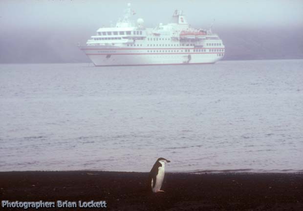 I shot a portrait of a lone Chinstrap
Penguin standing on the shore with the Hanseatic floating in the
distance.
I shot a portrait of a lone Chinstrap
Penguin standing on the shore with the Hanseatic floating in the
distance.
 We did not have time to get all the
way to the hangar, but we saw a lone figure walking toward us
from the decrepit building. It was Dad, returning from the far
side of the outpost. He had found an old, single-engine airplane
fuselage sitting out of site on the other side of the hangar. I
had missed my only chance to take a picture of an airplane in
Antarctica.
We did not have time to get all the
way to the hangar, but we saw a lone figure walking toward us
from the decrepit building. It was Dad, returning from the far
side of the outpost. He had found an old, single-engine airplane
fuselage sitting out of site on the other side of the hangar. I
had missed my only chance to take a picture of an airplane in
Antarctica.
People were no longer soaking in the puddle on the shore. The water temperature in the hole had risen to 140 degrees F., far too hot to get in.
We boarded the Zodiac and returned to the ship. We sailed back out through Neptune's Bellows, steered a course to the northeast, and headed for Livingstone Island, about forty miles away.
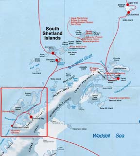 Map of the Antarctic Peninsula.
 Table of
Contents
Table of
Contents Send a message to Brian.