 Have you ever gone to a
place with a great view that won't fit in your camera's
viewfinder? These super-wide views reveal the broad vistas of the
American Southwest and the Antarctic in a way that no ordinary
photograph can. My panoramic prints are 8.2 inches tall and up to
42 inches wide.
Have you ever gone to a
place with a great view that won't fit in your camera's
viewfinder? These super-wide views reveal the broad vistas of the
American Southwest and the Antarctic in a way that no ordinary
photograph can. My panoramic prints are 8.2 inches tall and up to
42 inches wide.
Putting one of these panoramas on your wall is like installing
a bay window. They are printed on your choice of Epson Premium
Glossy Photo Paper or Epson Premium Luster Photo Paper using fade
resistant Epson Ultrachrome inks. They are delivered rolled in a
sturdy mailing tube. (Download a higher resolution picture by
clicking on any picture below. The text that appears on the
digital images does not appear on the prints.)
Goleta, California, February 4, 2004
Goleta Pier

Goleta Pier on a cold, clear February morning. The University
of California at Santa Barbara (UCSB) can be seen on the left
side.
| PAN031 Goleta Pier, 8.2" x 42", $33.00 |
|
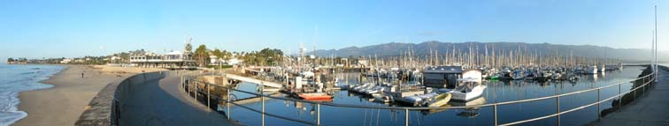
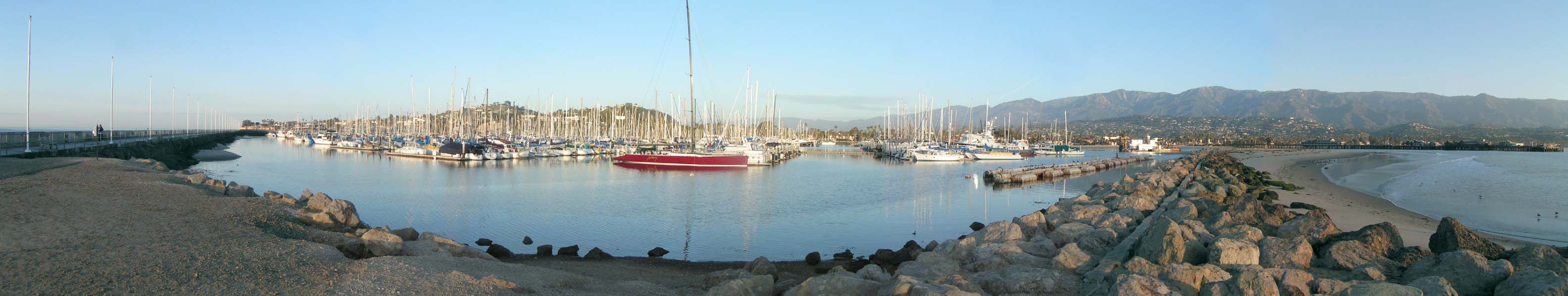
Santa Barbara, California, January 26, 2004
Santa Barbara Harbor #1

Santa Barbara Harbor on a cold, clear January morning. The
Santa Barbara Wharf can be seen to the right side of the rocky
jetty.
| PAN029 Santa Barbara Harbor #1, 8.2" x 42",
$33.00 |
|
Santa Barbara Harbor #2
Santa Barbara Harbor on a cold, clear January morning.
Leadbetter Beach can be seen on the left side of the picture.
| PAN030 Santa Barbara Harbor #2, 8.2" x 42",
$33.00 |
|
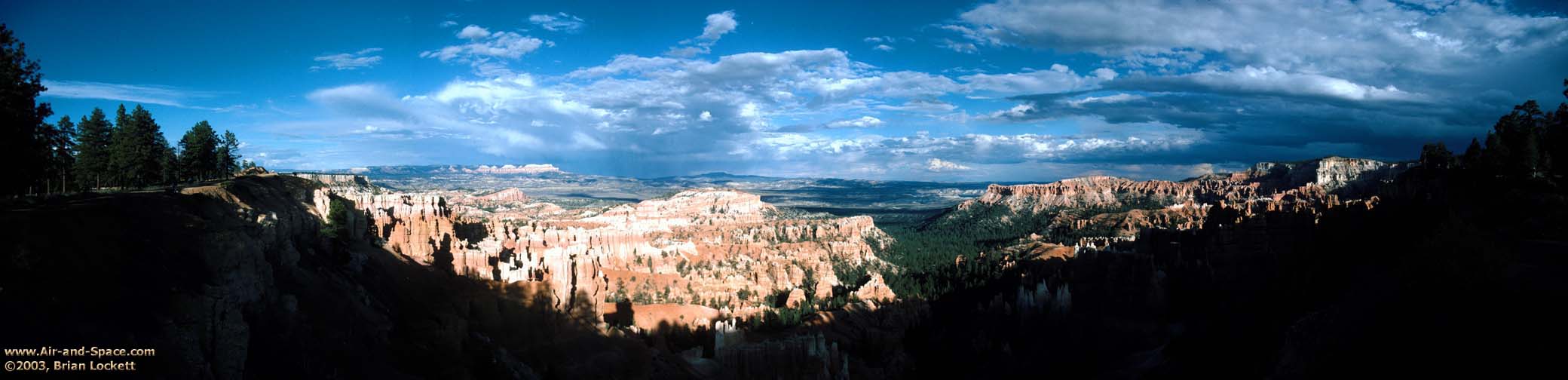
Bryce Canyon National Park, September 2003
Sunset from the rim, 8.2" x 33"
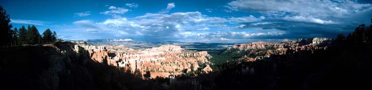
View from the rim of Bryce Canyon between Sunrise Point and
Sunset Point. Summer afternoon thunderstorms scrubbed the air so
clean that Navajo Mountain, eighty miles away on the far side of
Lake Powell, is visible in the far distance. The Kaipirowitz
Plateau is prominent on the horizon just above Ship Rock to the
left of center.
| PAN009 Bryce Canyon Sunset, 8.2" x 33",
$25.00 |
|
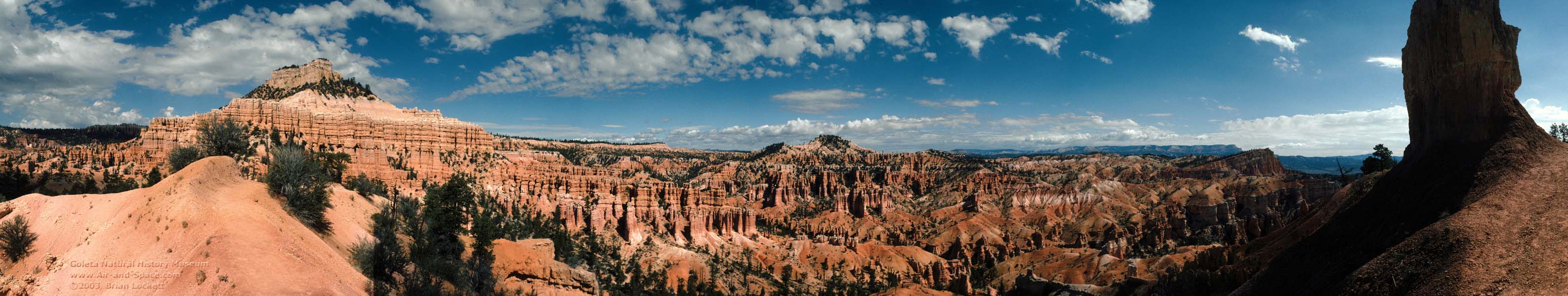
Fairyland Trail #1, 8.2" x 42"

The view inside the canyon is very different from the view
most visitors to the park see from the rim. Ship Rock and the
Kaipirowitz Plateau are visible to the right of center. The
sunset panorama above was taken from the rim of the canyon at the
left.
| PAN008 Fairyland Trail, Bryce Canyon #2, 8.2" x
42", $33.00 |
|
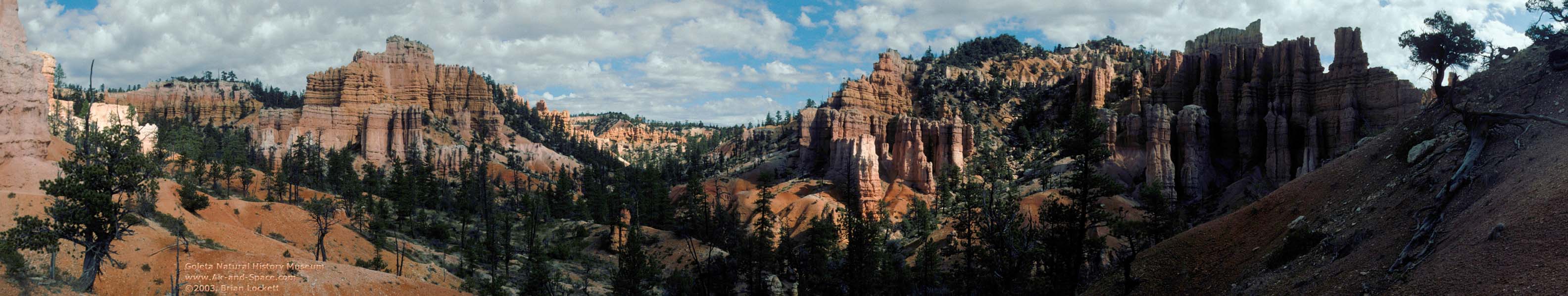
Fairyland Trail #2, 8.2" x 42"
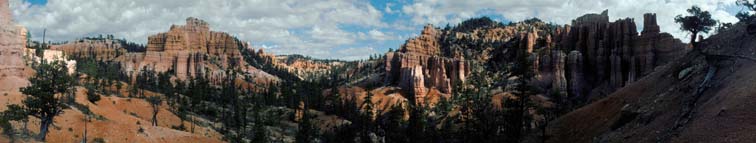
The Fairyland Trail leads down from the canyon on the left.
| PAN007 Fairyland Trail, Bryce Canyon #1, 8.2" x
42", $33.00 |
|
Antelope Valley, April 2003
California Poppies, 8.2" x 42"

California Poppies
| PAN010 California Poppies, 8.2" x 42",
$33.00 |
|
Joshua Trees, 8.2" x 42"

Goldfields carpet the desert floor between the Joshua Trees.
| PAN011 Antelope Valley Joshua Trees, 8.2" x
42", $33.00 |
|
Zion National Park, October 2002
Lava Point Overlook, 8.2" x 42"
Lava Point Overlook in Zion National Park.
| PAN027 Lava Point Overlook, 8.2" x 42",
$33.00 |
|
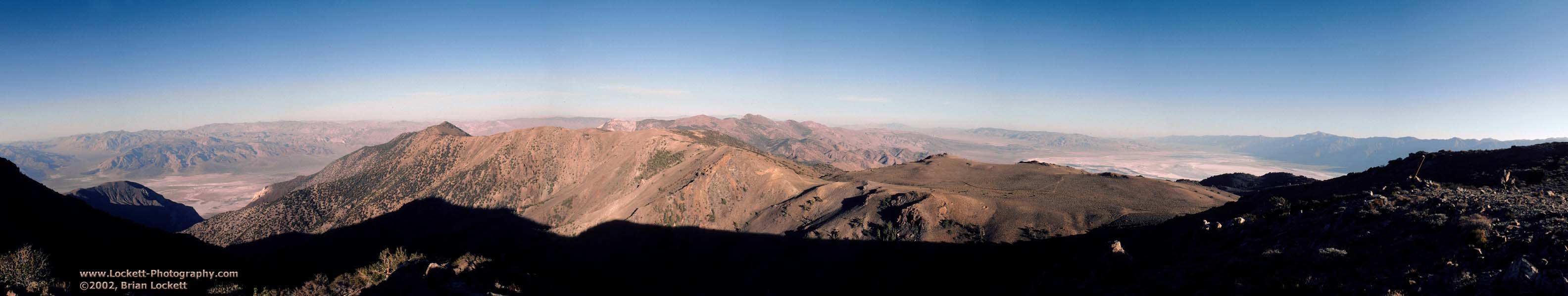
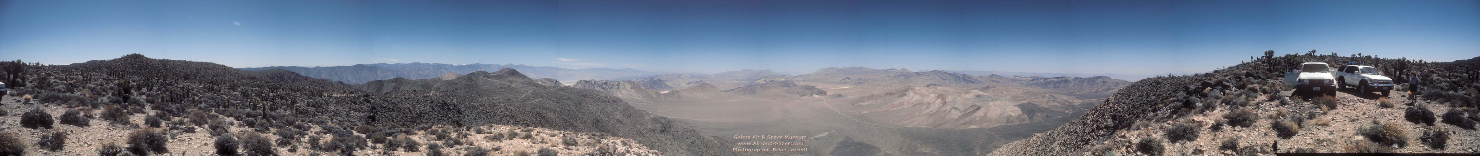
Inyo Mountains, June 2002
Saline Valley from the Inyo Mountains, 8.2" x 42"
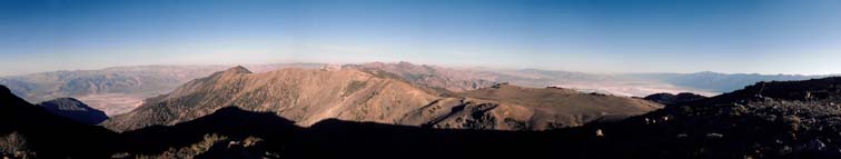
The view from an elevation of 9,600 feet near the Burgess Mine
at the crest of the Inyo Mountains. The bottom of the Saline
Valley in Death Valley National Park is 8,500 feet below at left.
Owens Valley and the Sierra Nevada are to the right.
| PAN025 Burgess Mine, 8.2" x 42", $33.00 |
|
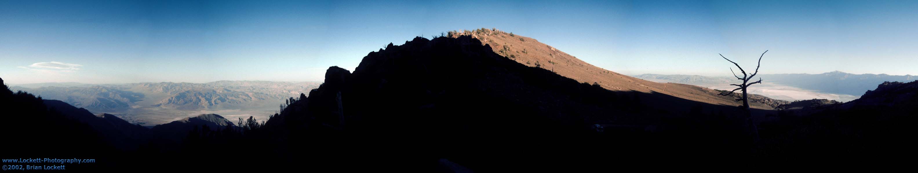
New York Butte Overlook, 8.2" x 42"
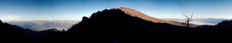
View from the end of the road at the base of New York Butte in
the Inyo Mountains. The bottom of the Saline Valley in Death
Valley National Park is 8,500 feet below at left. Owens Valley
and the Sierra Nevada are to the right.
| PAN026 New York Butte, 8.2" x 42", $33.00 |
|
Death Valley National Park, April 2002
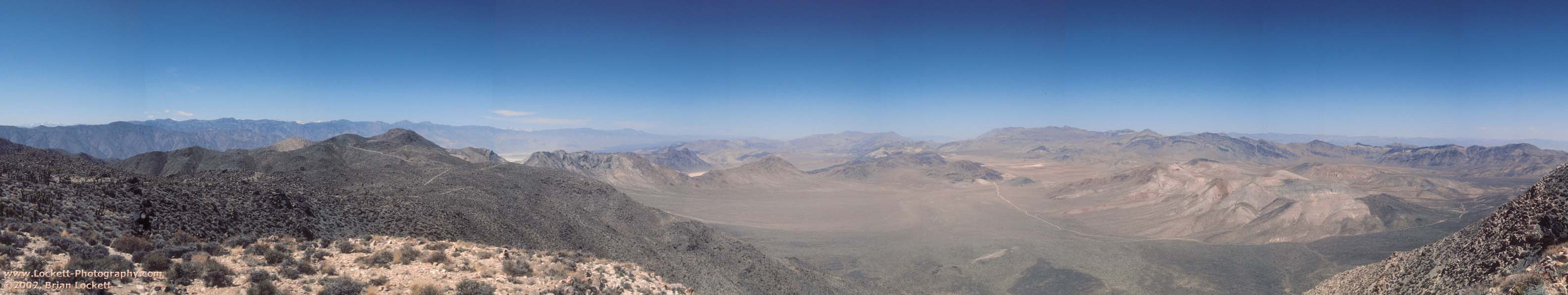
Hunter Mountain, 8.2" x 42"
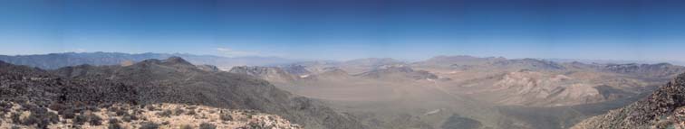
View from Hunter Mountain in Death Valley National Park in
April 2002. The valley on the right is Hidden Valley. Racetrack
Playa is just to the left of center. The Saline Valley is to the
left of Racetrack Playa. The highest peaks of the Sierra Nevada
are just visible over the Inyo Mountains on the left. Death
Valley is to the right.
| PAN024 Hunter Mountain, 8.2" x 42", $33.00 |
|
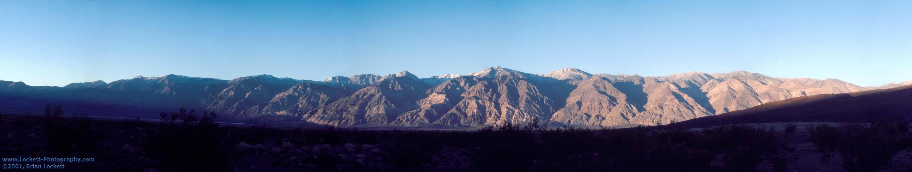
Death Valley National Park, November 2001
Inyo Mountain Sunrise from Saline Valley, 8.2" x
42"
First rays of the morning sun on the Inyo Mountains seen from
the Saline Valley in November 2001. New York Butte, Keynot Peak,
and Mount Inyo are the highest mountains in the range.
| PAN023 Inyo Mountain Sunrise, 8.2" x 42",
$33.00 |
|
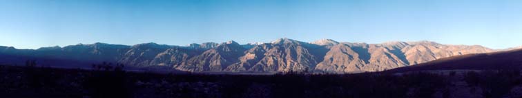
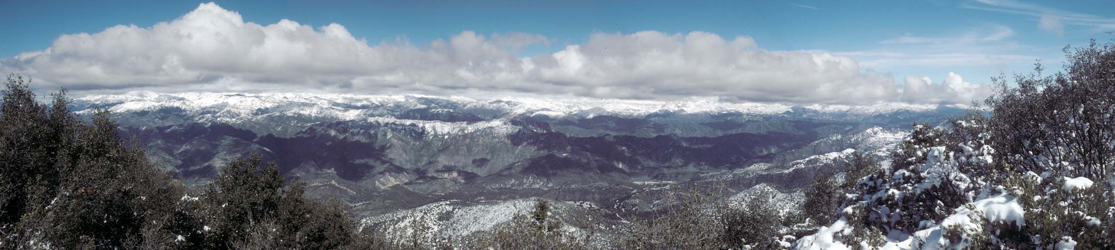
Santa Barbara County, February 2001
Snow in the Santa Barbara County back country, 8.2" x
37"
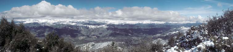
View looking to the north from the crest of the Santa Ynez
Mountains across the Santa Ynez Valley into the Santa Barbara
County back country on a rare snowy day. Gibralter Dam and
Reservior are visible just to the right of center.
| PAN015 Snowy Santa Barbara County 8.2" x
37" $29.00 |
|
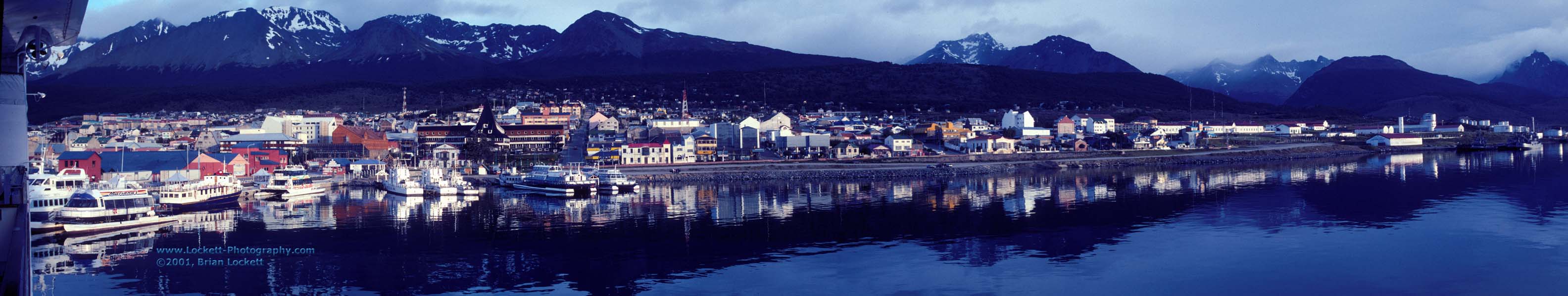
Argentina, January 2001
Ushuaia Harbor, 8.2" x 42"

Ushuaia, Argentina is the southernmost city on Earth.
Timberline is about 2,000 feet above sea level. It is a popular
departure point for Antarctic expedition cruises.
| PAN022 Ushuaia Harbor 8.2" x 42" $33.00 |
|
Antarctica, January 2001
Deception Island, 8.2" x 42"

Deception Island is a volcanic caldera in the South Shetland
Island group.
 |
A segment of the rim of the volcano has
collapsed, creating an entrance into the bay inside the
crater. The harbor is called Port Foster. The entrance to
the bay is known as Neptune's Bellows for the strong
winds that flow through it. The low spot on the rim to
the right of Neptune's Bellows is Neptune's window. The
sands of the beach of Whaler's Bay are heated
geothermally to over 160 degrees. The island has been
used as a whaling station, a German wartime raiding
outpost, and a British research station. This map is
copied from Antarctic Peninsula Map, published by Zagier
& Urruty Publications of Argentina. |
| PAN016 Deception Island 8.2" x 42" $33.00 |
|
Andvord Bay, 8.2" x 42"

Andvord Bay on the Antarctic Peninsula in January 2001. This
location can be seen at the center of the panorama below.
| PAN012 Andvord Bay, 8.2" x 42", $33.00 |
|
Departing Andvord Bay, 8.2" x 42"

Departing from Andvord Bay in January 2001.
| PAN021 Departing Andvord Bay, 8.2" x 42",
$33.00 |
|
Catalina Island, May 1999
Avalon Harbor, Catalina Island, 8.2" x 42"

Avalon Harbor, Catalina Island.
| PAN013 Avalon Harbor, Catalina Island, 8.2" x
42" $33.00 |
|
Phoenix, Arizona, July 1999
Thunderheads over Phoenix, 8.2" x 42"
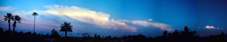
Cumulonimbus clouds tower over Phoenix, Arizona during the
monsoon season.
| PAN020 Thunderheads over Phoenix, 8.2" x
42" $33.00 |
|
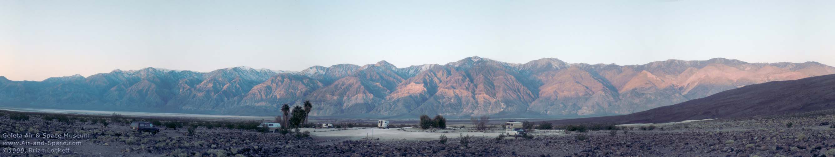
Death Valley National Park, March 1999
Inyo Mountain Sunrise from Saline Valley, 8.2" x
42"
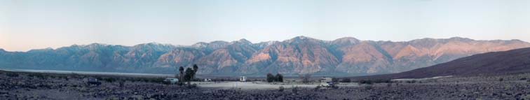
The Inyo Mountains at Sunrise, viewed from the Saline Valley
in Death Valley National Park.
| PAN019 Inyo Mountain Sunrise, Death Vally National
Park, 8.2" x 42" $33.00 |
|
Meteor Crater, Arizona, November 1998
Meteor Crater, 8.2" x 42"
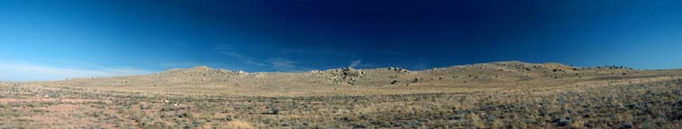
This view of the rim of Barringer Crater, better known as
Meteor Crater, reveals the uplifted rim of the crater, a blanket
of ejecta covering the lower slopes, and large boulders that were
excavated from inside the crater and landed on the outer slopes.
| PAN014 Meteor Crater, Arizona, 8.2" x 42"
$33.00 |
|
You can pay for the panoramic prints with your credit card
using the PayPal service. You can also pay for them with a check
or money order by printing out the mail-in
form and mailing it in with your payment.
| Shipping to
anywhere in the U.S.A. is: |
|
up to $49.99:
$50.00 to $99.99:
$100.00 to $199.99:
over $200.00:
|
$3.95 $5.95
$7.95
$9.95
|
| International orders
please inquire by e-mail
for shipping costs. |
| Sales tax of 7.75% will
be added to orders shipped to addresses in California |
| Please allow 2 to 3 weeks for delivery. |
 More of Brian
Lockett's photographs can be seen at the Goleta Air
& Space Museum.
More of Brian
Lockett's photographs can be seen at the Goleta Air
& Space Museum.


