
Forty Years ago in the X-15 Flight Test Program, February - March 1961 |
The NB-52A had been flown to the Boeing plant in Wichita on January 14 for maintenance. It was out of service during February and March 1961.
Major Bob White flew the last XLR-11 powered X-15 flight on February 7, 1961. Major Fitzhugh Fulton and Robert Mosley launched the X-15-1 from the NB-52B over Silver Lake, near Baker in eastern California. Stan Butchart manned the launch panel operator's station. Through a combination of optimal conditions, the XLR-11 engines burned twelve seconds longer than they had on any prior flight. White flew the X-15-1 to mach 3.49 (2,275 miles per hour), the highest speed that it attained with the XLR-11 engines. Following mission 1-20-35, the X-15-1 was shipped to North American in El Segundo to have its XLR-11 engines replaced with an XLR-99.
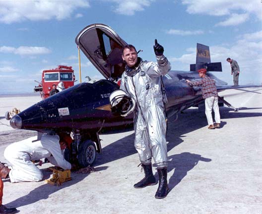 Major Bob White.
NASA took delivery of the X-15-2 from North American. It had been refitted with a round q-ball air data sensor machined from solid Inconel-X. Neil Armstrong had piloted the first flight of the ball nose on the nineteenth flight of the X-15-1 on December 9, 1960.
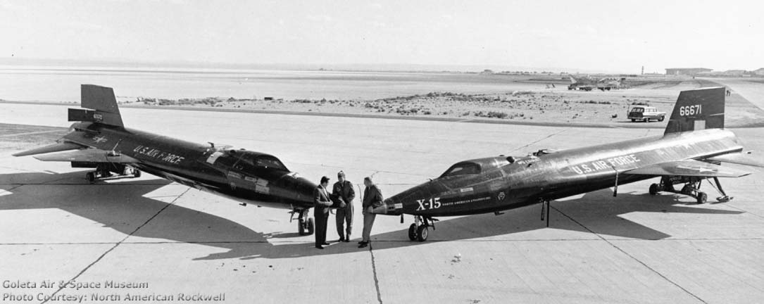 The first two X-15s show off their nose jobs.
Scott Crossfield is standing by the X-15-1 at the left and Neil
Armstrong lounges against the X-15-2 at right. Photo courtesy
North American Rockwell.
The first two X-15s show off their nose jobs.
Scott Crossfield is standing by the X-15-1 at the left and Neil
Armstrong lounges against the X-15-2 at right. Photo courtesy
North American Rockwell.
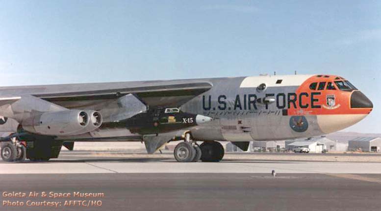
 Major Fulton and Captain Kuyk pilot the NB-52B
as it carries the X-15-2 on its first NASA mission on February
21, 1961. Major Bob White is at the controls of the X-15-2. This
is NASA's first attempt to launch the X-15-2 with its new XLR-99
engine. It is the first flight of the X-15-2 with the new ball
nose. Photo courtesy AFFTC/HO.
Major Fulton and Captain Kuyk pilot the NB-52B
as it carries the X-15-2 on its first NASA mission on February
21, 1961. Major Bob White is at the controls of the X-15-2. This
is NASA's first attempt to launch the X-15-2 with its new XLR-99
engine. It is the first flight of the X-15-2 with the new ball
nose. Photo courtesy AFFTC/HO.
This flight marked the beginning of the envelope expansion phase of X-15 operations. Joe Walker and Bob White would take turns pushing the X-15 to higher speeds and altitudes than it had reached before.
The flight was postponed by difficulties with the stable table system. The stable table used data from the instruments of the B-52 to establish a fixed frame of reference for the inertial navigation system of the X-15. It was a challenging task to get all of the instrumentation working together to fix the frame of reference. The process was referred to as erecting the stable table. Once the stable table was erect, it fed position and velocity data into the inertial navigation system of the X-15 before launch.
On this mission, the operation of the stable table was interrupted by the APN-81 doppler radar system shortly before launch.
The APN-81 doppler radar system measured the ground speed of the B-52 along its path and the speed of its drift across its heading as input to the stable table system. When the B-52 banked or pitched beyond certain limits the doppler radar system stopped measuring the ground speed and drift. After the B-52 stopped turning the doppler radar took some time to resume proper function. This was normal operation for doppler radar units on standard B-52 bombers.
The problem was that a typical X-15 launch mission began with a flight from Edwards AFB to the launch position followed by a 180 degree turn to the launch heading. The 180-degree turn took four minutes to complete. The doppler radar unit shut down during the turn, depriving the stable table system of necessary velocity information. Then it took too long to return to normal operation after the B-52 assumed the launch heading. Failure to maintain erection of the stable table in this critical period resulted in the abandonment of the attempt to launch the X-15.
 The NB-52B taxis with the X-15-2 before
take-off on February 24, 1961. Captain Charles Kuyk and Major
Kenneth Lewis are at the controls of the NB-52B. A horizontal
mission mark has been added for the aborted mission attempt made
three days earlier. As during the previous launch attempt, a
failure to maintain erection of the stable table resulted in a
launch abort. Photo courtesy AFFTC/HO.
The NB-52B taxis with the X-15-2 before
take-off on February 24, 1961. Captain Charles Kuyk and Major
Kenneth Lewis are at the controls of the NB-52B. A horizontal
mission mark has been added for the aborted mission attempt made
three days earlier. As during the previous launch attempt, a
failure to maintain erection of the stable table resulted in a
launch abort. Photo courtesy AFFTC/HO.
The X-15-2 was removed from the wing of the NB-52B and replaced by an instrumented pod. The pod was constructed from a leftover North American F-107 external fuel tank equipped with instrumentation to simulate the electronic functions of the X-15. It also contained accelerometers to measure the forces imposed on the X-15 while it was being carried by the NB-52. Captain Kuyk and Major Lewis piloted a flight of the NB-52B with the instrumented pod on March 1.
The first NASA flight of the X-15-2 with the ball nose and XLR-99 engine was successfully launched over Silver Lake on March 7, 1961. Captain Kuyk and Major Frank Cole piloted the NB-52B. Jack Russell manned the launch panel operator's station. Major White ploted the X-15-2 to a new maximum speed of mach 4.43 (2,905 miles per hour) and an altitude of 77,450 feet. It was the first flight of any aircraft faster than mach 4.
 X-15-2 sits on Rogers Dry Lake following a mission. Technicians
are replacing the nose wheels before towing it back to the NASA
hangar. Just barely visible is the NASA tailband, which has been
applied only to the left side of the vertical stabilizer.
X-15-2 sits on Rogers Dry Lake following a mission. Technicians
are replacing the nose wheels before towing it back to the NASA
hangar. Just barely visible is the NASA tailband, which has been
applied only to the left side of the vertical stabilizer.
Captain Vincent Baker and Captain Kuyk flew to Wichita to test fly the NB-52A on March 20 in preparation for its return to Edwards Air Force Base.
 NASA pilot Joe Walker was scheduled to fly the next X-15
mission. Walker had not flown the X-15 since the previous August.
The flight plan called for Joe Walker to attain 150,000 feet
altitude. Photo E-6682 Courtesy NASA Dryden.
NASA pilot Joe Walker was scheduled to fly the next X-15
mission. Walker had not flown the X-15 since the previous August.
The flight plan called for Joe Walker to attain 150,000 feet
altitude. Photo E-6682 Courtesy NASA Dryden.
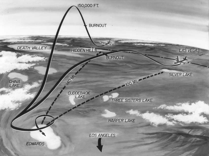 This
diagram illustrates typical high speed versus high altitude
flight profiles. The X-15 did not lose energy while it was out of
the atmosphere, so it traveled farther on high altitude flights
than on high speed flights. It was necessary to launch the X-15
farther from Edwards AFB on the high altitude flights, so Walker
would be launched over Hidden Hills Lake, near the Nevada border.
This
diagram illustrates typical high speed versus high altitude
flight profiles. The X-15 did not lose energy while it was out of
the atmosphere, so it traveled farther on high altitude flights
than on high speed flights. It was necessary to launch the X-15
farther from Edwards AFB on the high altitude flights, so Walker
would be launched over Hidden Hills Lake, near the Nevada border.
The NB-52B carried the X-15-1 aloft again on March 21 to launch Joe Walker's first X-15 flight with the big engine. Major Fulton and Captain Jack allavie were at the controls of the NB-52B. Trouble with the electrical systems of the NB-52B caused the launch attempt to be abandoned.
Captain Kuyk flew the other X-15 mothership back from Wichita to Edwards AFB on March 23. Lt. Colonel Richard Morgan acted as co-pilot on the cross-country flight. The NB-52A had received a complete facelift. All of the exposed metal surfaces were painted silver. The X-15 mission marks on the right side of the fuselage were replaced. The new mission marks were more closely spaced to make room for more mission marks to be added in the future.
Walker's first envelope expansion flight in the X-15 with the big engine was rescheduled for March 29, but high winds and trouble with the landing gear of the NB-52B caused the mission to be postponed for another day.
Major Fulton and Captain Kuyk launched Walker from the NB-52B on March 30. The engine failed to ignite on the first attempt, but it started after Walker reset the igniter. The X-15-2 reached an altitude of 169,000 feet, which was nearly 30,000 feet higher than any previous flight had gone.
Walker made the following comments about his observations of the earth from the extreme altitude:
I had plenty of time at the peak of the trajectory to make outside observations. The most impressive observation initially was the aspect of the sky overhead. The color I would describe as being a very deep violet blue, not indicative of a black shading, but an extremely dark bluish cast. I looked to the left and to the right and upward and outward to the horizon. Our flight path course was south southwest and hence I felt that the best chance, if it were possible, to observe stars in the daytime would be out the right hand side towards the northwest away from the sun. However, careful scanning as far as I could look to the side and upward did not reveal any points of light shining through the blue canopy overhead. This overhead sky was impressive in that it did not change shade from horizon to horizon, the color was almost uniform.
The next thing is that you have no doubt from external visual cues that you're really high up. The horizon is depressed far below the level line or plain of level about the aircraft. At the perimeter of vision, about the demarcation line between the sky and earth, there is a bright diffused band, caused I think, by looking through the atmosphere from overhead and across the tangent to the earth at the horizon and then back out through the atmosphere. This bright band is very sharply cut off at the top. However the blue from the sky can be observed through it as well as the shape and coloring connected with the earth's surface. I would say that you get the impression that this band extends above and below the apparent horizon, probably a little more above than below.
No difficulty is experienced in observing and identifying geographical features on the surface of the earth particularly in areas with which one is familiar. An outstanding aspect of this is the appreciation of relative heights or elevations; different levels of the surface. Mountains still stand out as mountains and looking down into the Los Angeles Basin, I could tell the smog as distinct from some low stratocumulus clouds along the seacoast. Areas which are heavily forested or under agricultural development, could be separated from those areas where nothing was growing, and once again, if one were familiar with the territory, this is even easier to pick out. I think anywhere if one had plenty of time to observe he could make these distinctions. Looking down vertically or near vertically features are very distinct. As one's gaze swings further and further out toward the horizon, of course, features become more blurred. It was a disappointment to me that there seemed to be an almost continuous string of low stratus along the coast all the way from left to right so that my efforts to identify prominent coastal features in order to arrive at an estimate of how far I could see to the side, were frustrated, however judging a little from the apparent angle towards San Diego, it was obvious that I was looking well down the coast of Baja, California and I could see equal distance up northerly along the coast. The curvature of the earth was very apparent.
The time of the flight was just after 10:00 am, hence the sun was shining at a near vertical to the plane of the surface over which I was flying. Under these conditions, features ranging down to medium size were easily identified. Cities, small lakes, and the features I mentioned before, could be distinguished. Also it was obvious to me that things had a sort of brightness about them which was above and beyond that lighting enabling the surface features to be seen, apparently once again some diffusion of sunlight due to passing through the atmosphere. Also the exceptional clarity of vision for long distances is easily appreciated. The texture and associated visual cues of the ocean are easily identified and in fact, this was so apparent that I didn't spend much time looking at it, however the general aspect looking away from the sun was of a dark satiny appearance. It was a bright sheen even though the water was of a dark color. As to land color in this area, the majority are shades of grays and browns, some tinges toward mild reddish cast, but generally sandy aspect. Vegetation is no longer a rich green color, it goes to a dark gray black.
This was to be the last altitude record set by the X-15. Yuri Gagarin was launched on the first Vostok mission on April 12, eclipsing all previous absolute height and speed records.


 Books about
the X-15 available from
Books about
the X-15 available from 
 Angle of Attack : Harrison Storms and the Race to
the Moon by Mike Gray. The biography of Harrison Storms, who
was instrumental in the development and operation of the X-15.
Angle of Attack : Harrison Storms and the Race to
the Moon by Mike Gray. The biography of Harrison Storms, who
was instrumental in the development and operation of the X-15.
 At the Edge of Space : The X-15 Flight Program
by Milton O. Thompson. The story of test flying the X-15 from the
point of view of the pilot.
At the Edge of Space : The X-15 Flight Program
by Milton O. Thompson. The story of test flying the X-15 from the
point of view of the pilot.
*The first position of the mission number identifies which X-15 was involved, the second number indicates how many times that X-15 had been launched, and the third number indicates how many times it had been carried by an NB-52.
Send a message to Brian
Go to home page of the Goleta Air & Space Museum.